
SwitzerlandMobility: The best bike route planner for Switzerland
SwitzerlandMobility is the official platform for non-motorized transport in Switzerland and Liechtenstein. Whether hiking, cycling, mountain biking or skating - here you will find the most beautiful routes for your leisure activities. With detailed maps, official signposts and a user-friendly app, route planning is made easy.
In this article, we clarify all the relevant questions about SwitzerlandMobility. What exactly is SwitzerlandMobility? Who is behind it? How are the routes created, how are they maintained and why is SwitzerlandMobility superior to other bicycle route planners? We also show where the journey is heading, what new developments can be expected and why a SwitzerlandMobility Plus subscription is worthwhile.
SwitzerlandMobility: A unique network for non-motorized traffic
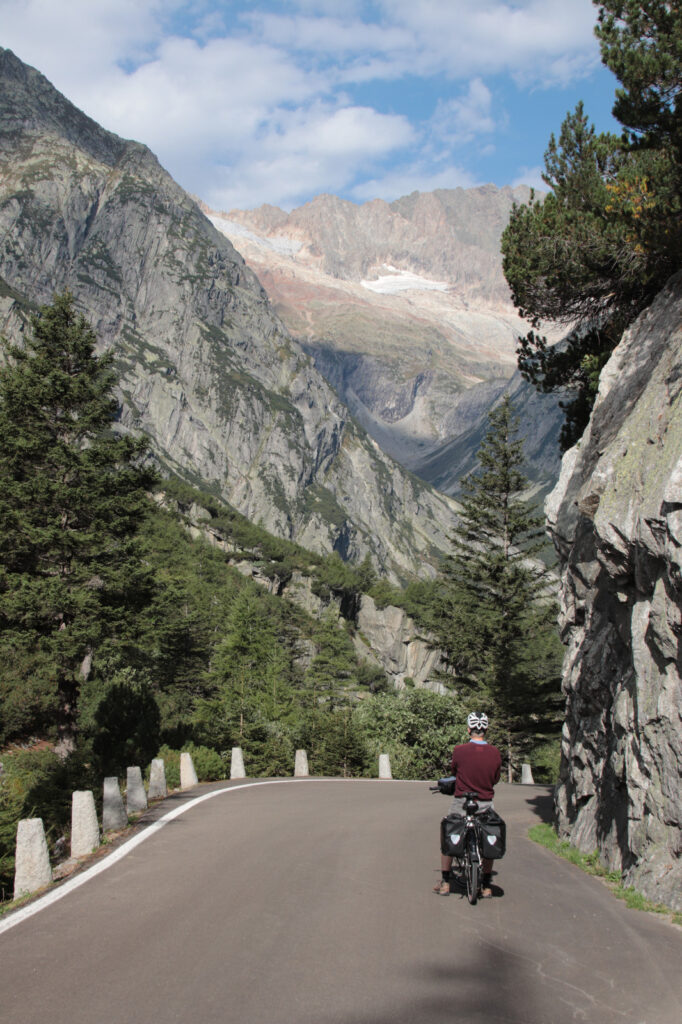
SwitzerlandMobility has been the official network for non-motorized transport in Switzerland and Liechtenstein since 2008. The offer covers summer and winter activities: From hiking, cycling, mountain biking, skating and canoeing to winter and snowshoe hiking, cross-country skiing and sledging.
What makes SwitzerlandMobility unique worldwide is its collaboration with the federal government, the cantons, numerous specialist organizations and partners from the tourism and mobility sectors, which enables a uniformly signposted route network that only exists in this form in a few other places. The platform offers not only inspiration, but also reliable route information with over 120,000 geo-referenced photos.
“A coherent and safe route network with so many forms of mobility, which is officially and locally signaled and prepared with detailed and verified information, is exceptional.” - Ronja Bächle, SwitzerlandMobility
The story behind SwitzerlandMobility
The roots of SwitzerlandMobility lie in the Solothurn cycle paths that were created between 1991 and 1993 to mark Switzerland's 700th anniversary. Founding members Markus Capirone and Thomas Ledergerber wanted to create safe and family-friendly routes - car-free, clearly signposted, with accompanying maps and guidebooks to draw attention to the landscape and cultural features as well as the tourist infrastructure.
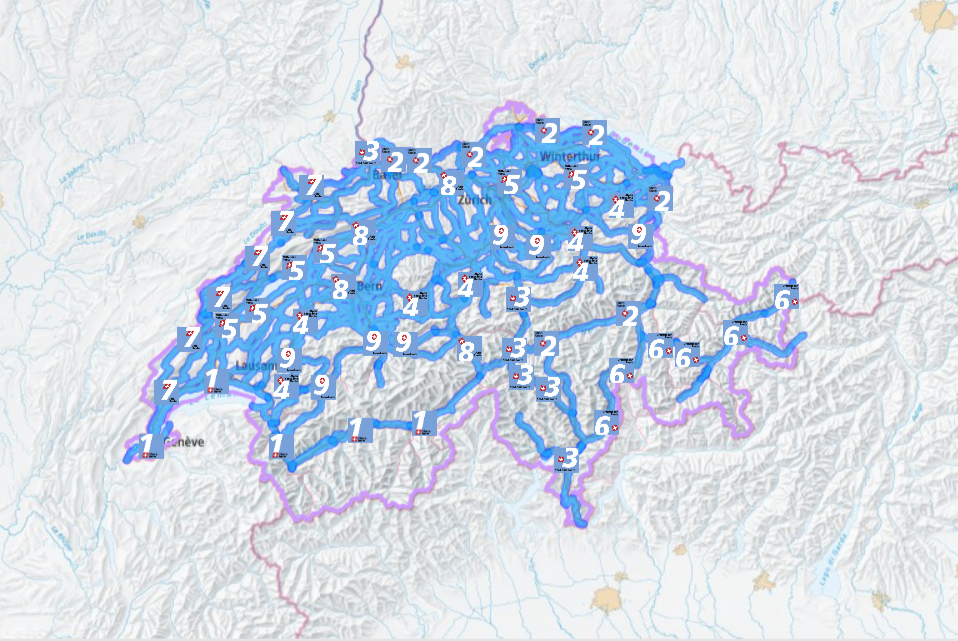
The cycle routes were so successful that the project was extended to the whole of Switzerland. Together with the Swiss Tourism Association, 9 national cycle routes were realized and the Veloland Foundation was established, which later became the SwitzerlandMobility Foundation. The vision: slow traffic for leisure and tourism at the highest level. Today, the route network covers 36,700 kilometers in summer, of which 11,732 kilometers are Veloland routes (as of May 2025).
Cycling country: structure and scope
Cycling in Switzerland currently comprises 11,732 kilometers and 126 routes. These are divided into:
- National routes (e.g. Rhine route): Numbered in single digits (1-9), lead through the whole of Switzerland in several stages.
- Regional routes: Numbered in two digits (e.g. 21, 33), lead in several stages through different cantons.
- Local routes: Numbered in three digits (e.g. 305), they are ideal for day trips.
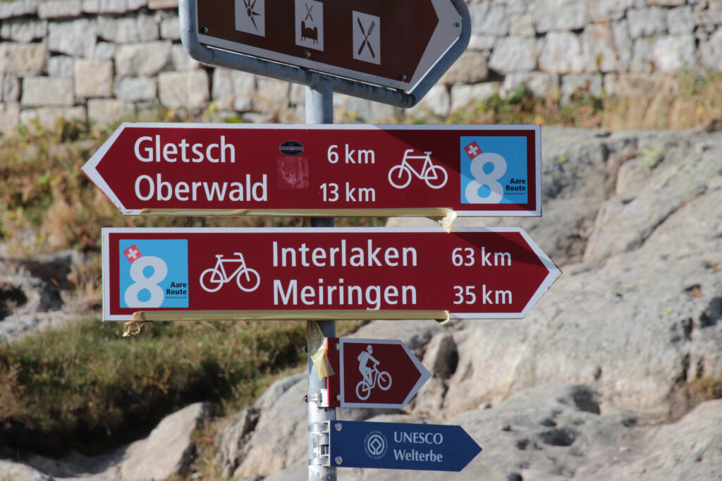
Routes 1 (Rhone Route), 2 (Rhine Route), 3 (North-South Route) and 35 (Liechtenstein Rhine Valley Route) are part of the EuroVelo network and offer connections to international long-distance cycle routes.
On schweizmobil.ch the routes can be filtered according to various criteria and the appropriate tour suggestion selected (filter top right).
With a SwitzerlandMobility Plus subscription, the selected route can be saved directly in the personal tour list and the corresponding map section can be downloaded offline in the app. The journey can be planned using the direct link to the SBB timetable. The route information also contains a wealth of additional information such as accommodation options, bookable offers (bike tour including luggage transport), places of interest, stage locations, bike hire and bike service stations. Thanks to the local signposting, nothing can go wrong along the way.
Quality assurance and maintenance of the route network
The route network is maintained in close cooperation with the cantons. The existing route network is reviewed in annual workshops and new routes are planned. Subsequently, the geodata, route information such as texts and photos are updated and, last but not least, the signposting on site. Signposting is the responsibility of the cantons, while SwitzerlandMobility defines national planning principles and operates the central information platform
“The design of the routes is in the hands of the cantons. SwitzerlandMobility brings together the relevant players from tourism, leisure and mobility.” - Ronja Bächle, SwitzerlandMobility
The best routes for bicycle travelers
By working closely with tourism organizations and professional associations, SwitzerlandMobility ensures that the routes are scenically and culturally attractive. The routes are regularly reviewed and adapted to meet the needs of users.
Creation of new routes
New routes are planned by the cantons in collaboration with local tourism organizations and specialist organizations. Once the approval process has been successfully completed, the geodata is recorded, content created and the signposting implemented. New summer routes are published in March, winter routes in November.
SwitzerlandMobility Plus: Your personal tour planner
SwitzerlandMobility Plus gives you additional functions for your route planning:
- Offline maps: Save maps and routes for offline use.
- Draw your own tours: Plan individual routes with altitude profiles and times.
- GPX import/export: Import or export GPX tracks for your navigation device.
- Share tours: Share your planned tours with friends
These functions are available both in the app and on the website. By purchasing SwitzerlandMobility Plus, you support the promotion of non-motorized transport in Switzerland and Liechtenstein as well as the expansion of the cycling and mountain bike network, good local signposting and reliable information.
The future of SwitzerlandMobility
SwitzerlandMobility is continuously working to improve its services. The focus is on the quality of the routes, especially in cycling country. The aim is to get more people interested in cycling by creating safe and attractive offers.
New developments in cycling country
Currently, 20 to 30 new summer routes and 10 to 15 winter routes are added each year. These usually include 2 to 6 new Veloland routes.
In addition, SwitzerlandMobility has launched the “Future Cycling Country” program to strategically review the cycling country together with the cantons and develop it further as part of the cycle route network planning. The focus here is on aligning the routes with the needs of target groups such as families with children, beginners, excursionists and experts.
Another major project over the next few years is the integration of a national cycle and mountain bike network. As with hiking, all official and signposted cycle and mountain bike trails (with the red signposts) are to be recorded and shown on the map.
Why SwitzerlandMobility is the best route planner
SwitzerlandMobility offers a unique, officially signposted route network that is regularly checked and updated. SwitzerlandMobility Plus gives you additional functions for individual route planning. Close cooperation with official bodies guarantees the highest quality and safety on the routes. SwitzerlandMobility is the ideal companion for anyone who wants to discover Switzerland on two wheels.
“All SwitzerlandMobility routes are officially and locally signposted. This sets us apart from other route planners that rely on user-generated offers. Some of these lead along illegal paths, through nature reserves or private property and are not signposted. The SwitzerlandMobility routes are regularly checked and maintained so that there are no nasty surprises along the way.” - Ronja Bächle, SwitzerlandMobility
The range of obstacle-free trails is also unique. Thanks to the cooperation with Procap Switzerland, people with disabilities can also enjoy their favorite activity on numerous obstacle-free hiking trails. The obstacle-free paths are designed without any major natural or structural obstacles. The information provides details on barrier-free access options and wheelchair-accessible toilets, possible danger spots, gradients and trail conditions. There is also an app (MyWay Pro, only available for IOS) that guides blind and visually impaired people along the obstacle-free paths using spoken texts. More about the barrier-free offer.
What are you waiting for?
Get SwitzerlandMobility Plus, plan your next bike route, rent a bike and enjoy the Touring bike or a gravel bike from Pedalmondo and find out for yourself why SwitzerlandMobility is the best bike route planner in Switzerland!